
Living Shorelines
Alabama Living Shorelines Restoration and Monitoring Project
Investigators: PI’s: Ronald Baker (USA/DISL), Bret Webb (USA).
Project Manager: Alex Rodriguez (DISL).
Duration: March 2021 - February 2026.
Funding: NOAA RESTORE, ADCNR
Coastal ecosystems across the Gulf of Mexico are threatened by shoreline erosion and the loss of highly productive oyster reefs, submerged vegetation, and emergent marsh wetlands. Private homeowners and environmental managers use a variety of shoreline restoration strategies to protect coastal systems and in recent years ‘living shoreline’ strategies have gained traction. Living shorelines incorporate natural materials such as wetland vegetation and oyster reefs to reduce nearshore wave activity, stabilize shoreline sediment, and promote ecosystem services. Living shorelines provide an alternative to traditional ‘shoreline hardening’ techniques and avoid some of their downfalls. However, most projects have been implemented somewhat independently, with variable monitoring requirements. This limits our ability to compare the effectiveness or sustainability of different restoration techniques across living shoreline sites. For this project, we are implementing a comprehensive monitoring program that measures the effectiveness of multiple large-scale Alabama living shoreline restoration projects across multiple ecological dimensions, including effects on shoreline erosion, wetland vegetation composition, submerged vegetation density, oyster reef development, and fisheries enhancement. Through this monitoring program, we are measuring the ‘success’ of each living shoreline project, describing the benefits and trappings of alternative restoration strategies, evaluating the efficacy of different monitoring methods, and ultimately helping to inform the design and siting of future restoration projects based on a clearer picture of the successes and limitations of previous individual projects.

M.S. student, Matheus, and 2022 REU intern, Claire, process samples from shoreline seines.
All samples collected under AL Dept. or Marine Resources permit no. 2022-01-02

Ph.D. student, Aaron, monitors bivalves at a living shorelines site.

Aaron, Chris, and Matheus pulling a seine net at a shoreline site. Seine samples help us assess nekton communities across living shoreline, reference, and control sites.
All samples collected under AL Dept. or Marine Resources permit no. 2022-01-02
Limits to Oyster Development on Breakwater Structures
Investigators: PI’s: Ronald Baker and Aaron Bland (USA/DISL).
Duration: April 2023 - April 2024 and February 2025 - August 2026
Funding: Garden Club of America (2023 - 2024) and Mississippi-Alabama Sea Grant (2025 - 2026)
Coastal marsh restoration often involves building structures intended to seed oyster reefs, thereby improving water quality and habitat value at nearshore marsh environments. In practice, oyster reef development on constructed breakwaters is highly variable, and it is often unclear which ecological factors prevent oysters from settling and surviving on structures. We aim to identify factors limiting oyster development on breakwater structures to inform future project design and siting for more effective oyster restoration. By identifying the factors that limit individual oyster development on breakwater structures, this project will help identify tangible restoration decisions that may improve oyster reef development.

Ph.D. student, Aaron, installing caged ceramic tiles seeded with oyster spat in the field.

Lab manager, Alex, counts oyster spat on deployed tiles.

Research technician, Grace, retrieving deployed oyster tiles.
Characterizing Fisheries Communities and Habitats Along Restored Living Shorelines
Investigators: PI: Alex Rodriguez (DISL), Ronald Baker (USA/DISL), Kelsey Hofheinz (USA/DISL), and Pat David (DISL)
Project Manager: Kelsey Hofheinz (USA/DISL)
Duration: October 2023 - May 2024
Funding: Pensacola and Perdido Bays Estuary Program
Living shorelines (LS) provide many benefits over traditional hard armoring. One of the most widely stated but least tested benefits is the enhancement of habitats for fisheries species. This project will use the highly visible public LS restorations of Project Greenshores I & II in Pensacola, FL as demonstration sites to quantify the fish habitat benefits of these projects. Underwater video surveys will be used to sample the fish communities across the seascapes at the project sites and adjacent unrestored areas. By comparing fish densities at restored seascapes, adjacent bare substrates, and hardened shorelines, we can quantify how many more fish are present due to the habitat restoration, and which habitats they prefer, to better inform future living shoreline designs.
We will develop a project website to highlight the project and its findings, allowing interested people to interact with the data. Icons on maps of the sites will allow users to view videos of fish on the various habitats in the restored seascape, and drill down to view summaries of the data, such as the range of species found in each habitat, their relative abundance, and distributions. Demonstrating habitat enhancement values of highly visible public restoration projects will help guide future restoration projects, foster a greater appreciation of LS approaches, and encourage their wider support and uptake in the community.

Kelsey, Grace, and Alex conducting underwater video surveys at Greenshores II.
Photo by Logan McDonald from PPBEP.
A clip from our underwater video surveys of a Mugil cephalus
(Striped mullet) swimming across oyster reefs at Greenshores II.
A clip from our underwater video surveys of Lutjanus griseus
(Grey snapper/Mangrove snapper) swimming outside breakwaters at Greenshores I.
.png)
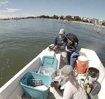
Kelsey prepping video cameras while Alex drives to our sampling location.
Shoreline Habitat Assessments of Nature-Based Solutions at Coffee Island, AL
Investigators: PI: Ronald Baker (USA/DISL) and Alex Rodriguez (DISL)
Duration: July 2023 - June 2027
Funding: NOAA awarded through The Nature Conservancy
Coffee Island, a barrier island in Mississippi Sound, Alabama, is home to living shoreline restoration efforts spanning over a decade. These efforts continue to provide habitat benefits for oysters and fish but no longer provide erosion protection for the shoreline. The rapid erosion of the island’s shoreline threatens the integrity of the marsh complex and the island’s buffering capacity for coastlines along the northern shores of the Mississippi Sound. Long-term monitoring of Coffee Island’s shorelines showed that larger, longer breakwaters are needed to help protect the shoreline and habitats of barrier islands. This project will implement a 5,000-ft living shoreline breakwater to help create and enhance habitat at the southeast shoreline of Coffee Island. The Baker Lab will lead pre- and post-construction shoreline habitat assessment and biological permit compliance.