
Restoration Monitoring
Restoration Monitoring at Graveline Bay Marsh
Investigators: PI: Alex Rodriguez (DISL) and Ronald Baker (USA/DISL)
Duration: Summer 2022 - 2025
Funding: Town of Dauphin Island awarded through Moffatt & Nichol
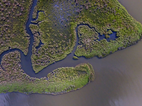
Graveline Bay on Dauphin Island is the site of an existing salt marsh that currently provides essential habitat to numerous species and offers coastal protection to the bordering residential community. In an effort to create up to 24.3 hectares of marsh area and provide shoreline infrastructure, a living shoreline restoration design is being constructed throughout late 2022. This project focuses on establishing baseline conditions of the existing marsh and monitoring post-restoration change following project completion to assess vegetation communities, elevation change, and overall spatial extent of the marsh. Assessing these metrics also affords an opportunity to develop and refine low-cost options for monitoring with unoccupied aircraft systems (UAS). UAS provide rigorous solutions to common monitoring challenges in salt marsh habitats, such as site fragmentation, dense vegetation, and difficult on-the-ground navigation. Merging low-cost UAS workflows with traditional monitoring methods provides more comprehensive means of assessing change and informing adaptive management.

We use open-source structure-from-motion photogrammetry software to create full-site imagery of the marsh at Graveline Bay. Extracting data from this mosaicked image and other assets lets us assess site-scale change.

Imagery collected in late fall of 2023 showing the marsh mound restoration design during the construction phase of the project.
.jpg)
Alex focuses on the wetland vegetation while other team takes elevation data with a RTK
.png)
Drone pilot, Alex, flies our Phantom 4 Multispectral drone to capture imagery across Graveline Bay.
Monitoring Living Shoreline Restoration Performance in Pensacola Bay
Investigators: PI: Alex Rodriguez (DISL) and Ronald Baker (USA/DISL)
Duration: April 2022 - April 2027
Funding: NOAA awarded through Moffatt & Nichol
The 2010 Deep Horizon oil spill and associated response activities caused benthic secondary productivity and salt marsh habitats along Florida’s Panhandle to suffer. In the spring of 2022, living shoreline restoration began at Greenshores II in Pensacola Bay to offset the corresponding injuries to natural resources. Restoration efforts at Greenshores II seek to protect and create reef and salt marsh habitats and promote reef development for bivalves and other invertebrates in the bay. As a result of these goals, approximately 3.5 acres of breakwaters and 9.2 acres of restored marsh habitat occupy this site. The Baker Lab monitors the performance of these restoration efforts at Greenshores II by evaluating breakwater structural stability, invertebrate habitat utilization, salt marsh habitat protection from erosion, and native marsh vegetation establishment.
.jpg)
Summer and Kelsey surveying wetland vegetation growth at GreenShores

Alex takes aerial imagery of Ronnie and Kate recording elevation data using a RTK
Monitoring Shoreline Restoration from Nature-Based Solutions in the Perdido Watershed
Investigators: PI: Ronald Baker (USA/DISL)
Project Manager: Alex Rodriguez (DISL)
Duration: May 2023 - April 2027
Funding: NOAA awarded through The Nature Conservancy
Shallow estuarine habitats, including salt marshes, seagrass, and oyster reefs, provide essential fish habitat (EFH) for many of the nation’s most productive and valuable commercial and recreational fisheries and their prey. These critical habitats become degraded or lost entirely to the development of hardened shorelines, leading to subsequent losses of fisheries production and other ecosystem services. Some parts of the Perdido Bay system already have extensive shoreline hardening, with 19% of the Alabama Perdido Bay and 55% of the nearby Pensacola Bay hardened. Driven by rapid population growth along the Bay, continued shoreline development will lead to further significant losses of EFH and the full range of ecosystem services they provide.
The Perdido Watershed Habitat and Community Resilience Initiative is a large-scale, multi-site project aimed at enhancing ecosystem and community resilience in the Perdido watershed across Alabama and Florida through the integrated planning, implementation, and monitoring of multiple restoration approaches and techniques. The Baker Lab leads shoreline restoration monitoring efforts through shoreline mapping and shoreline classification along the Perdido Bay watershed.
.jpg)
The Baker lab using the seine net to collect samples in Perdido Bay
.jpeg)
Alex and Natalie recording data in Perdido Bay
Living Shoreline Restoration Monitoring at Aloe Bay, Dauphin Island
Investigators: Ronald Baker (USA/DISL) and Alex Rodriguez (DISL)
Duration: 2024 - 2028
Funding: Town of Dauphin Island awarded through Moffatt & Nichol
Aloe Bay, located along the north side of Dauphin Island, is home to two shorelines known as El Dorado Project Site and De Soto Project Site. Both shorelines are receding rapidly as a result of erosion. This project seeks to provide a line of defense against wave activity to protect eco-tourism and education areas, increase estuarine productivity in Aloe Bay, and improve community resilience by protecting infrastructure in the economic hub of Dauphin Island. The Baker Lab will lead baseline monitoring, construction monitoring, and three years of living shoreline performance monitoring.

Post-planting of Spartina alterniflora at Aloe Bay